Clear Lake Aquifer System
Background and Purpose
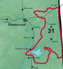 Significant irrigation development has occurred in this area because of cooperation between the U.S. Fish and Wildlife Service and the Sheridan County Conservation District that resulted in a groundwater reservation. Aquifer monitoring has been the key to this cooperation and is planned to be continued indefinitely. Additional aquifer definition needs to be accomplished to provide data to allow additional development without impacting water bodies and migratory bird habitat managed by the Medicine Lake Wildlife Refuge.
Project Scope
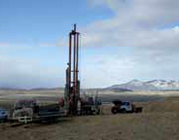
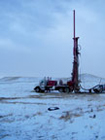
Drilling and well construction are needed to better define the geology of the aquifer system. Evaluation of aquifer test data, response tests, water-use monitoring, water-level monitoring, and water chemistry sampling/analyses are needed to define the hydrogeology and better define the hydraulic connection between the aquifers and wetlands. New project data along with groundwater/surface-water elevation data from recent studies throughout the area will be used to construct a groundwater flow model. The ultimate goal will be a detailed aquifer management model available for future water management decisions including prediction of development impacts.
For more information contact:
- Jon Reiten
406.272.1608
 jreiten@mtech.edu
 - Kevin Chandler
406.272.1605
kchandler@mtech.edu
GWIP Personnel Assigned: Currently unassigned
Publications and Reports:
- Clear Lake Aquifer System — GWIP Nomination
by Sheridan County Conservation District (pdf file)
Contact information :
- Where to find us in Butte and Billings
- for general GWIP program information
 Ginette Abdo
or 406.496.4152
- for general MBMG information
Cathy McKillips
or 406.496.4167