Buried River channel aquifers (Sidney)
Background and Purpose
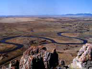
A buried-channel aquifer from 1 to 4 miles wide and 26 to 40 miles long underlies the Yellowstone Valley through Richland County. Recharge appears to be dominated by artificial recharge associated with flood irrigation. The aquifer is a source for stock, domestic, industrial, and community supplies. There is a significant need to understand and manage this resource to protect existing supplies and surface-water resources while developing additional water for communities, agriculture, and industry. Since this aquifer is artificially recharged, changing land uses and methods of water distribution may significantly impact the aquifer and existing water resources.
Project Scope
This study will examine what area or areas may be most important for aquifer recharge, and provide recommendations for land-use or operational activities in such areas to maintain or maximize recharge.
For more information contact:
Jon Reiten
406.272.1608
 jreiten@mtech.edu
Kevin Chandler
406.272.1605
kchandler@mtech.edu
GWIP Personnel Assigned: Currently unassigned
Publications and Reports:
- Buried River channel aquifers (Sidney) — GWIP Nomination by Richland County Conservation District (pdf file)
Contact information:
- Where to find us in Butte and Billings
- for general GWIP program information
Ginette Abdo
or 406.496.4152
- for general MBMG information
Cathy McKillips
or 406.496.4167