Background and Purpose
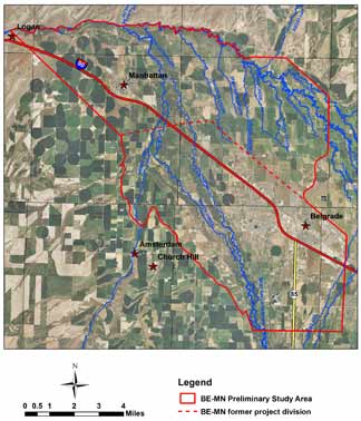
Two study areas were combined to comprehensively examine the similar geology and issues of the lower Gallatin Valley. This combination will increase efficiency and facilitate modeling of this area, which includes the hydrologic outlet for the basin. Work in the Belgrade area was begun in 2009 and in Manhattan in 2012. Expected completion date for this united effort is 2015.
New development, both rural and municipal has increased water demand throughout this area. Some rural residents report decreased flows in spring-fed streams that are tributaries of the East Gallatin River. The area is intensely irrigated although land use and irrigation methods are changing. Questions include:
- Can the groundwater resource support increased municipal and agricultural use?
- Has development upstream and upgradient of Manhattan caused changes in local hydrology?
- What are the long-term effects of development and changing irrigation methods?
In order to provide more accurate descriptions of the geology, hydrologic properties of the aquifers, available water supplies and the effects of stresses on the groundwater and surface water in the Manhattan-Belgrade study area, GWIP has been installing stream gauging stations and measuring stream flows at many locations along the Gallatin, East Gallatin and major tributaries. We have added new wells to the groundwater monitoring network. Test wells have been installed at four locations throughout the study area. These test sites will be used to conduct long-term aquifer tests to generate detailed data for use in computer models of the study area. A numerical groundwater model will be constructed to simulate the observed hydrogeologic conditions and to evaluate the response of the groundwater system to specific stresses, such as new wells or municipal systems. The final products will include a publicly available interpretive report and a groundwater computer model.
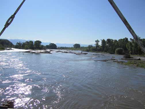
The confluence of the East and West Gallatin Rivers, as seen from the bridge at Nixon Gulch facing east.
Project Duration: November 2009 to June 2015
GWIP Personnel Assigned:
Tom Michalek – Team Leader/Hydrogeologist
406.496.4405
![]() tmichalek@mtech.edu
tmichalek@mtech.edu
Mary Sutherland – Groundwater Modeler /Hydrogeologist
406.496.4410
![]() msutherland@mtech.edu
msutherland@mtech.edu
Project Factsheet (pdf file)
Recent Presentations:
Publications and Reports: (none yet available)
Project data available here:
http://mbmggwic.mtech.edu/sqlserver/v11/menus/menuProject.asp? mygroup=GWIP&myroot=BWIPMN&ord=1&
In the News:
![]() Investigating Groundwater in Montana Informs State Water Policy Decisions • Published 21 February 2016
Investigating Groundwater in Montana Informs State Water Policy Decisions • Published 21 February 2016
Contact information :
- Where to find us in Butte and Billings
- for general GWIP program information
 Ginette Abdo
or 406.496.4152
- for general MBMG information
Cathy McKillips
or 406.496.4167