Beaverhead to Twin Bridges Groundwater Investigation
Background and Purpose
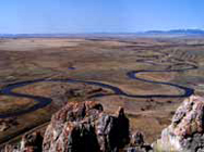
This proposal is for the Lower Beaverhead River between Beaverhead Rock and the community of Twin Bridges. This reach is part of the upper Missouri River Basin Closure. The Beaverhead River study above Beaverhead Rock to Dillon was just completed, and many of the same water management challenges likely exist below Beaverhead Rock, particularly due to increased use of and changes in irrigation systems. This includes new wells, greater demands on the surface water, irrigators changing to pivot irrigation systems, and Fish Wildlife and Parks demanding more in-stream flow for fisheries. The anticipated results of increased demand on water resources are a cumulative effect on existing and proposed stream flows in the Beaverhead River.
Project Scope
This project will tie the upper reach and lower reach of the Beaverhead together hydrogeologically to better understand the dynamics of groundwater and surface-water interactions. It would also be beneficial to know the groundwater recharge mechanisms of the lower reach, and the flow dynamics of water through the area. In addition, the information provided by the study would allow for a more efficient assessment of new permit and change applications. It would also allow for a better understanding of the success of mitigation/offset requirements in this closed basin.
Tentative GWIP Personnel Assigned:
Ginette Abdo – Team Leader/Hydrogeologist
406-496-4152, ![]() gabdo@mtech.edu
gabdo@mtech.edu
Contact information:
- Where to find us in Butte and Billings
- for general GWIP program information
 Ginette Abdo
or 406.496.4152 - for general MBMG information
Cathy McKillips
or 406.496.4167