You may order the maps you need by calling us at 406.496.4167, using our regular mailing address:
Montana Bureau of Mines
and Geology
Publication Office
1300 West Park Street
Butte, MT 59701-8997
or by ordering directly over the internet from our online catalog.
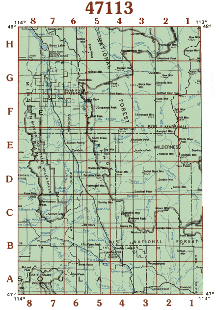
Click on the area of interest within the degree block to find the name of each 7½ topo sheet.
| A1 |
Ovando Mountain |
E1 |
Prairie Reef |
| A2 |
Ovando |
E2 |
Haystack Mountain |
| A3 |
Woodworth |
E3 |
Big Salmon Lake East |
| A4 |
Salmon Lake |
E4 |
Big Salmon Lake West |
| A5 |
Belmont Point |
E5 |
Holland Peak |
| A6 |
Gold Creek Peak |
E6 |
Condon |
| A7 |
Wapiti Lake |
E7 |
Peck Lake |
| A8 |
Stuart Peak |
E8 |
Piper-Crow Pass |
| B1 |
Spread Mountain |
F1 |
Slategoat Mountain |
| B2 |
Dunham Point |
F2 |
Amphitheatre Mountain |
| B3 |
Morrell Mountain |
F3 |
Pagoda Mountain |
| B4 |
Seeley Lake East |
F4 |
Marmot Mountain |
| B5 |
Seeley Lake West |
F5 |
Sunburst Lake |
| B6 |
Upper Jocko Lake |
F6 |
Swan Peak |
| B7 |
Belmore Sloughs |
F7 |
Salmon Prairie |
| B8 |
Gold Creek |
F8 |
Cedar Lake |
| Cl |
Danaher Mountain |
G1 |
Three Sisters |
| C2 |
Hahn Creek Pass |
G2 |
Bungalow Mountain |
| C3 |
Crimson Peak |
G3 |
Cathedral Peak |
| C4 |
Morrell Lake |
G4 |
Meadow Creek |
| C5 |
Lake Inez |
G5 |
String Creek |
| C6 |
Lake Marshall |
G6 |
Thunderbolt Mountain |
| C7 |
Gray Wolf Lake |
G7 |
Cilly Creek |
| C8 |
St. Marys Lake |
G8 |
Porcupine Creek |
| D1 |
Trap Mountain |
Hl |
Pentagon Mountain |
| D2 |
Pilot Peak |
H2 |
Trilobite Peak |
| D3 |
Una Mountain |
H3 |
Whitcomb Peak |
| D4 |
Shaw Creek |
H4 |
Spotted Bear Mountain |
| D5 |
Holland Lake |
H5 |
Tin Creek |
| D6 |
Cygnet Lake |
H6 |
Connor Creek |
| D7 |
Hemlock Lake |
H7 |
Swan Lake |
| D8 |
Mount Harding |
H8 |
Yew Creek |
top of map